In the late fall of 1833 the Joseph Walker party found itself literally between a rock and a hard place. Walker and his men had left the annual Green River trappers' rendezvous earlier in the summer. They had been ordered to explore to the headwaters of the Humboldt River and cross the Sierra Nevada Mountains, trapping beaver along their way into the valleys of California. By late October, however, snow was beginning to accumulate at pass level in the Sierras and a pitched battle with Paiute natives in the Humboldt Sink in west central Nevada prevented any thoughts of returning to the East. The only choice was to quickly find a route over mountains previously unexplored by European Americans. The experience crossing the Sierras was chronicled by a member of the party, Zenas Leonard, based on regular entries from a diary he kept for over five years exploring and trapping in the West. The excerpt below describes the group’s first two days in the Sierra Nevadas.
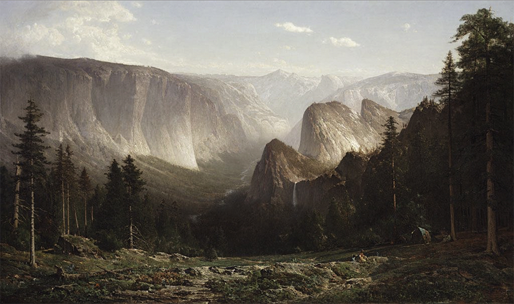
The Walker route over the Sierras may have been over Virginia Pass and into the northeast corner of what today is part of Yosemite National Park in California, as suggested in the map; although a recent book by Scott Stine argues for a more northerly route (Stine, 2016). If, indeed, the Yosemite route is true, it is doubtful that the explorers saw much of Yosemite Valley - perhaps the western most portion near where Leonard reported seeing "some trees of the Redwood species, incredibly large." Nevertheless, as a historical source Leonard's narrative is gripping. It makes an ideal point of entry into a classroom treatment of western exploration including confrontations with the native population, dramatic details of surviving a mountain crossing at the onset of winter, and vivid descriptions of the geography encountered.
And how does GIS lend itself to this topic? One of the more important aspects of maps is the geographical context they provide and that is clearly significant in this case. While the two-dimensional image presented at right gives some sense of the terrain the explorers faced, GIS provides the opportunity for a more expansive 3-D exploration of the route. What better way, short of being there, for students to appreciate the steepness of the grade, the shear granite cliffs, and the impending snow than following the Walker route up Green Creek and over Virginia Pass into the heart of the Sierra Nevada Mountains. Click to start the movie or to open a 3-D version of the map and join the ascent of the Walker party into the Sierras.
The use of GIS (geographic information systems) in the history classroom provides more than geographic context, though. As you will see in the following pages GIS provides a way for students to approach large sets of spatially related data in a way that was simply not possible in the secondary classroom until recently. Additionally, use of GIS provides a rich medium for students to build spatial reasoning and critical thinking skills. And, finally, GIS activities engage students in a highly enjoyable and motivational way. Each of these aspects of the use of GIS software along with effective classroom strategies for their use and a look at some of the technical issues related to the development of lesson materials are discussed. Classroom examples are organized around materials found on the In Time & Place website, a collection of primary and secondary resource materials related to a growing number of topics in American history. These materials include:
In this regard it is important to remember that while GIS is a valuable new tool for middle and secondary students that provides new and unique ways of exploring and understanding our past, the traditional resources of history have lost none of their value. The examples included here intentionally integrate a rich variety of these sources to help make this point.
|