
Salmon were a central part of life in the Columbia River Basin for the first Americans and, to a lesser extent, to early European immigrants; that is, as long as the salmon populations existed in abundance and held a central place in the region's economy. That is no longer the case and has not been so for nearly a century. Depletion of the salmon population by over fishing, construction of dams, agriculture and resource extraction such as logging and mining have all played a role in the decline.
This unit explores each of these aspects of the history of salmon in the Columbia Basin allowing you to become familiar with:
- Native American legends about the origin of salmon and the role of salmon in their lives
- the native culture that early European explorers encountered
- the impact of the canning industry in the late 19th and early 20th centuries
- dams on the Columbia and their impact on salmon
- environmental factors and changes affecting the salmon population
- the story of "Lonesome Larry" and a recent resurgence in salmon numbers
- a look at salmon recovery plans and activities
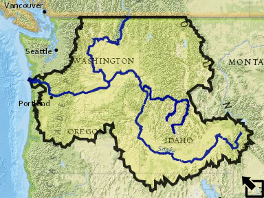
But first, open the large version of the Columbia Basin map above and acquaint yourself with the geography of the Columbia River Basin as you address the questions below.
1) Identify the three major rivers in the Columbia Basin.
2) Identify the mountain ranges that form the rim of the basin that drains to the Pacific Ocean at the mouth of the Columbia River near Astoria, Oregon
3)Turn on the Lewis & Clark layer in the map. The red route represents the expedition's westward journey. As you can see by following the route, Lewis and Clark entered the Columbia River drainage south and west of Butte, Montana. Switch to the imagery or topographic basemap and zoom in on the area where they entered the Columbia Basin. Describe the topagraphy of the region and explain how you know that they were crossing a divide from one river basin to another - in fact, the continental Divide.
4) Notice in the map that the northern boundary of the Columbia Basin is shown along the United State - Canada border and that obviously the Columbia River continues into Canada. Print a copy of the map so that British Columbia is included and sketch on it the actual boundary of the Columbia River Basin beyond the Canadian border. Be prepared to explain how you determined the boundary.