Unit Objectives
- Develop a clear and accurate mental image of the geography of the Great Plains.
- Understand the historical, geographical, and cultural factors that led to the Dust Bowl.
- Understand personal experiences of participants in the Dust Bowl and the ensuing migration west by analyzing related primary documents.
- Use GIS software to explore connections between place, weather and culture as they relate to the Dust Bowl.
Related National Standards
|
Common Core standards apply
to the activities in this unit.
Identify those that are appropriate to the particular materials you select to use from this set of history related standards compiled as part of the American Social History Project City University of New York. |
||
|
|
|
|
GIS Activities
GIS assignments are part of the last two activities in this unit. The activities make use of ArcGIS Online, an internet software that runs on most browsers. If you do not have an an ArcGIS account and would like to have one you can sign up for a free personal account here.
The Dust Bowl Project files are also available to download for ArcGIS Desktop:
The data and shapefiles in the various map layers are from a variety of sources:
Great Plains States
Minnesota Population Center. National Historical Geographic Information System: Pre-release Version 0.1. Minneapolis, MN: University of Minnesota 2004.
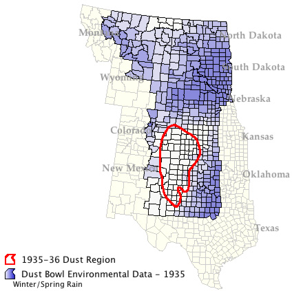
Dust Bowl Environmental Data - 1935
Gutmann, Myron P. GREAT PLAINS POPULATION AND ENVIRONMENT DATA: ENVIRONMENTAL DATA [Computer file]. ICPSR version. Ann Arbor, MI: University of Michigan [producers], 2005. Ann Arbor, MI: Inter-university Consortium for Political and Social Research [distributor], 2005.
Dust Bowl Counties Census Data - 1930, 1940
Gutmann, Myron P. GREAT PLAINS POPULATION AND ENVIRONMENT DATA: DEMOGRAPHIC, SOCIAL, AND AGRICULTURAL DATA [Computer file]. ICPSR version. Ann Arbor, MI: University of Michigan [producers], 2005. Ann Arbor, MI: Inter-university Consortium for Political and Social Research [distributor], 2005.
1935-36 Dust Region
derived from a map in Donald Worster, The Dust Bowl: The Southern Plains in the 1930s, 25th Anniversary Edition, (New York: Oxford University Press, 2004), p 31.
% Sandy Soil
from Sand, Silt, Clay Fraction at the Soil Information for Environmental Modeling and Ecosystem Management site, College of Earth and Mineral Sciences, Pennsylvania State University .
Rainfall
Mapped rainfall data from the PRISM Climate Group, Oregon State University, created 4 Feb 2004.
North America Relief Map, 1940
Tom Patterson, “Physical Map of the Coterminous United States”, available at Shaded Relief.
Additional Resources
Geoff Cunfer, “Causes of the Dust Bowl,” in Anne Kelly Knowles, editor, Past Time, Past Place: GIS for History, (Redlands, California: ESRI Press, 2002), pp. 93-103.
Donald Worster, Dust Bowl: Southern Plains in the 1930s, New York: Oxford University Press, 1979.
American Experience: Surviving the Dust Bowl, PBS, 1998.
Contact
Your comments and suggestion about these materials are more than welcome.
If you have ideas for additional topics that would lend themselves to the approach taken here, please pass them along. I'd enjoy collaborating with you.