Unit Objectives
- Describe the geography of California's Mother Lode region.
- Identify and describe ways in which native Americans interacted with their Mother Lode environment.
- Understand the impact of changing gold mining practices on
the environment of the Mother Lode.
- Diagram and explain the movement of mercury through the environment from its use in mining to human consumption.
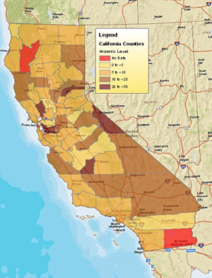
- Examine how arsenic concentrations result from gold mining and how it impacts the environment.
- Analyze the various factors that have contributed to changing the forest cover of the Mother Lode.
- Examine how agricultural practices have changed over the last century and a half in the Mother Lode.
- Describe changing demographic patterns in the Mother Lode.
Related National Standards
|
Common Core standards apply to the
activities in this unit.
Identify those that are appropriate to the particular materials you select to use from this set of history related standards compiled as part of the American Social History Project City University of New York. |
||
|
|
|
|
GIS Activities
GIS investigations are part of many of the activities in this unit. These investigations make use of ArcGIS Online, an internet software that runs on most browsers. If you do not have an an ArcGIS account and would like to have one you can sign up for a free personal account here.
The El Dorado Project files are also available to download for ArcGIS Desktop:
Download El Dorado Project Data
The data and shapefiles in the various map layers are from a variety of sources:
California State & County Level Data
California state and county shape files including hydro, imagery, and base map data from the Cal-Atlas Geospatial Clearinghouse
California Arsenic & Cancer Related Data
Arsenic level data from Alex N. Helperin David S. Beckman Dvora
Inwood, California's
Contaminated Groundwater: Is the State Minding the Store?
(Los Angeles: Natural Resources Defense Council, 2001).
Cancer related data from National Cancer Institute, State
Cancer Profiles, 2005-2009.
Vegetation
Historic photos of El Dorado County from the Wieslander Vegetation Type Maps & Photographs, University of California 2005.
Vegetation data for 1934 and 1945 from the Wieslander Vegetation Mapping Project, University of California, Berkeley, 2005.
Vegetation data from 1977 from the California Department of Forestry and Fire Protection Historic CALVEG Project.
Contemporary data from the Cal-Atlas Geospatial Clearinghouse
Mining
Mine data from USGS, Mineral Resources On-Line Spatial Data.
Principle Area of Mine Pollution data from the California Department of Conservation.
Agriculture
Agricultural census data from 1997 from the USDA Census of Agriculture Historical Archive.
Data from earlier years from the Census of Agriculture, U.S. Department of Commerce, Bureau of the Census.
El Dorado Hills Aerial Photos
Stitched from USGS, Earth Explorer photos and
from "Clarksville.sid", Cal-Atlas Geospatial Clearinghouse.
Additional resources
Those interested in learning more will find that the Internet offers a variety of interesting materials.
-
Calisphere The 1848-1865: The Gold Rush Era section contains an extensive collection of materials on the Gold Rush in California
-
Search the Library of Congress: American Memory Collection for resources on the California gold rush.
Students and teachers wishing to learn more about the impact of gold mining in California may want to read the following:
-
James J. Rawls and Richard J. Orsi, A Golden State: Mining and Economic Development in Gold Rush California (Berkeley: University of California Press, 1999).
Contact
Your comments and suggestion about these materials are more than welcome.
If you have ideas for additional topics that would lend themselves to the approach taken here, please pass them along. I'd enjoy collaborating with you.