Dam Removal?

Dam removal and restoration of the Hetch Hetchy Valley was first seriously proposed in 1988 by Donald Hodel, President Bush's Secretary of the Interior. Hodel's proposal has been followed over the last two decades by a series of increasingly more comprehensive studies by a variety of groups and agencies including:
• Environmental Defense
• Restore Hetch Hetchy
• California Departments of Water Resources and Parks & Recreation
• US Department of the Interior

The activity below provides an opportunity to explore the existing San Francisco water and power system, a glimpse into the conclusions of the studies listed above and the data on which they are based, a chance to weigh the pros and cons of dam removal, and the task of formulating your own position.

Water & Power for San Francisco

To say that the impact of removing O'Shaughnessy Dam on San Francisco's water and power system would be significant would be a gross understatement. The existing system serves water and power needs not only in the city, but several other Bay Area communities as well, provides power to meet San Francisco's public utility needs and those of the Turlock and Modesto Irrigation Districts, and provides flood control and irrigation to Sacramento and San Joaquin Valley farmers and towns. To begin to understand the impact of dam removal you need a basic understanding of the existing system. The Hetch Hetchy GIS project file contains several layers of maps and related data. Load the file along with the Water & Power Layers table and let's take a look:
1) Where are the largest dams in the system? What is their total storage capacity? Not all of the water stored in the system's reservoirs goes for drinking water. You may have noticed in the attribute table that the Don Pedro Dam is owned by the Turlock Irrigation District. San Francisco has rights to 740,000 acre feet of water per year. The remainder is for irrigation. What is the adjusted total available to San Francisco?

My World
ArcGIS
• Click on the Dams 2009 layer in the layer list.

• Click on the table icon ( ) to open the layer's data table.

• Click on the category heading to sort ascending; a second time to sort descending.

• Right click on the layer in the table of contents and select Open Attribute Table.

• Right click on any category heading to get a list of options for examining the data:

• Select Sort Ascending (or Descending) to sort values in the table on the category selected
• Select Statistics for a set of summary statistics and bar graph
2) Create a new AGE field in the Dams table. What is the average age of the systems dams?

My World
ArcGIS
• Click on the Analyze tab and select to Add Fields to Layer by Math Operation

Complete the form as indicated below:

• Click on the Statistics icon ( ) and check on the Mean value in the AGE column.

• Right click on YRBUILT the layer in the table of contents and select Open Attribute Table

• Select Options at the bottom of the table and Add Field:

• Give a descriptive field name (10 letters or less, no spaces)
• Select type LONGINT for a whole number value
• Click OK

• To calculate the new ages of the dams right click on the new AGE field heading and select Field Calculator...

• Now enter the formula in the text box:

• Type 2009
• Single click on the minus sign
• Double click on YRBUILT
• Click Done.

• Right click once again on the AGE heading and select Statistics to check the mean value.

3) Locate the three power plants in the system. What is the total maximum power output? The total possible power output in California is approximately 325,000 millions of kilowatt hours per year. What percentage of this total does each of the plants in the San Francisco system provide?
4)
Treatment of water in the San Francisco system is minimal because of the purity of most of the water at its source in the Sierras. Where are the two treatment plants in relation to sources outside the Sierras?
5) The pipe and tunnel pieces of the system are extensive. How extensive? The map you have is not exact in terms of the location of each section of tunnel and pipeline. You can, however, measure to get an estimate of the total length of pipeline and tunnels that bring water across the state to the Bay Area.

My World
ArcGIS
• Click on the Measure tool ( )

• Single click on one end point, single click on the end of segments along the way, and double click on the other endpoint Segment lengths and the total length are displayed in the bar at the bottom of the screen.

• Click on the Measure tool ( )

• Single click on one end point, single click on the end of segments along the way, and double click on the other endpoint Segment and total lengths are displayed in the Measure window:

Putting the Pieces Together


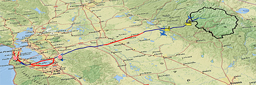
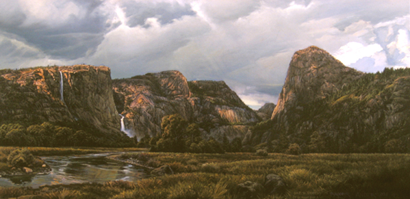
The issues around the removal of O'Shaughnessy Dam and restoring Hetch Hetchy Valley are complex. Analysis is well served by teamwork on both sides of the issue -- pro and con. The diagram at right suggests a division of the effort. Click on the headings for outlines of the responsibilities of team members and for descriptions of each piece of work that needs to be produced leading to a class debate. There is a bibliography of possible resources.

Take a Stand

The final piece of this activity is for you to weigh in on the issue personally. Write an opinion piece (e.g. - a letter to the editor or a Congressional leader, a newspaper op-ed article) in which you argue for or against dam removal. Support your argument with any of the evidence gathered as part of the debate. Check the evaluation guidelines for the assignment.

image by permission of Brooks Anderson, BrooksAndersonArt.com "Hetch Hetchy: Requiem for a Valley," in the collection of Principia College, Elsah, Illinois.

Last modified in May, 2009 by Rick Thomas